
Location: 12.8N, 124.1E
Altitude: 1,565 masl (5,133 feet)
Altitude: 1,565 masl (5,133 feet)
Jump-off point: Bulusan Lake, Bulusan, Sorsogon
Days Required: 1-2 days / Hours to summit: 6 hours
Specs: Major climb / Difficulty: 5/9 / Trail Class: 3

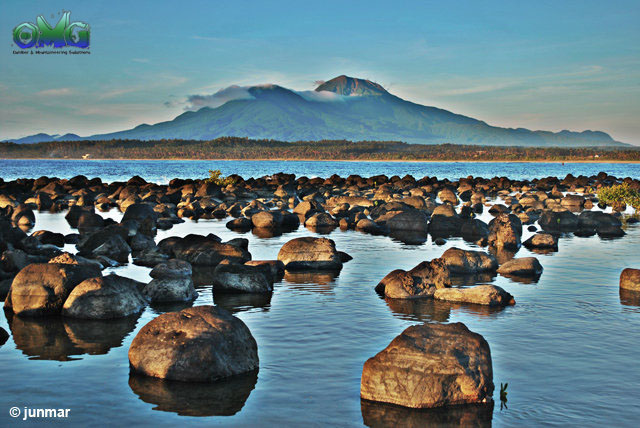
A view of Mt. Bulusan from Dancalan Beach, Gubat, Sorsogon
Bulusan Volcano is located at the south central part of Sorsogon Province. It covers a surface area roughly 400 sq. km. and towers to about 1559 m. above sea level. The volcano forms part of the Bicol Volcanic Chain which stretches from Camarines Norte in the north to Sorsogon in the south. The chain, sometimes called volcanic belt, is composed of active and geologically young volcanoes most probably related to the Philippine Trench.

A view of Mt. Bulusan Crater (Blackbird Lake) from the Summit
Bulusan is clasified as a composite volcano and is made up of lava flows and domes. It is flanked by several cones namely: Mt. Homahan, Mt. Binactan, Mt. Batuan, Mt. Juban, Mt. Calaunan, Mt. Tabon-Tabon, Mt. Calungalan and Mt. Jormajan. Beside the active volcano is an old ridge called Sharp Peak which is 1215 m. high and 1.8 km. to the northeast. Between Bulusan and Jormajan is the Natakop lava dome.
Recent eruptions have been recorded that happened in 2006, 2007, 2010 and 2011.
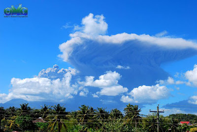
Bulusan Volcano Eruption last Feb. 20, 2011 at around 9AM

Bulusan is clasified as a composite volcano and is made up of lava flows and domes. It is flanked by several cones namely: Mt. Homahan, Mt. Binactan, Mt. Batuan, Mt. Juban, Mt. Calaunan, Mt. Tabon-Tabon, Mt. Calungalan and Mt. Jormajan. Beside the active volcano is an old ridge called Sharp Peak which is 1215 m. high and 1.8 km. to the northeast. Between Bulusan and Jormajan is the Natakop lava dome.
Recent eruptions have been recorded that happened in 2006, 2007, 2010 and 2011.


Sources of information:
No comments:
Post a Comment