Monday, March 7, 2011

The Beat of My Heart

Are you thinking of committing suicide because of your boring and routinary life? My friend, I may have a better suggestion for you.. An alternative that most probably has the same degree of difficulty as suicide, but (and I guarantee you this) the outcome is far more beneficial than putting an end to your promising life.

I kind of felt the same.. but since I reached my first summit last May 22, 2010, my life has changed.. completely. When somebody asked me to join a Mt. Buluisan climb, I didn’t hesitate.. because I was tired of doing the same things.. I must say though, and warn you in advance, mountain climbing is not an easy task.. hahaha.. Oh no.. NEVER.. hahaha.. I did sweat blood on my way up..I held on tight to my whole body which was on the verge of collapse. Every inch of my flesh begged me to stop. But I didn’t. And when I reached the top, my whole being wasn’t really able react to what was there.. Beauty beyond words.

Julio and Sara


I can stay mad with everything that has happened to me on my way up and down Mount Bulusan. It was EXHAUSTING in every sense of the word...T_T.. I got hungry, and thirsty, and my legs got so scratched that it looked like chopping board due to sharp leaves.. But how can I stay mad with all the beauty I’ve witnessed and realized? T_T

I have been asking my trekmates of why they are climbing..And none of us can really answer why.. But what keeps us from doing so.. climbing mountains.. despite the hustles and difficulties... Well you can just imagine what’s in there that is so addictive..Because we just can’t tell you..But you can join us.. on our next trek and you can find out for yourself...:)

OMG's first climb at Mt. Bulusan

words by Sara Em

Wednesday, March 2, 2011

Mt. Bulusan / Bulusan Volcano


Location:  12.8N, 124.1E
Altitude:  1,565 masl (5,133 feet)
Jump-off point: Bulusan Lake, Bulusan, Sorsogon
Days Required: 1-2 days / Hours to summit: 6 hours
Specs:  Major climb / Difficulty:  5/9 / Trail Class:  3

A view of Mt. Bulusan from Dancalan Beach, Gubat, Sorsogon


Bulusan Volcano is located at the south central part of Sorsogon Province. It covers a surface area roughly 400 sq. km. and towers to about 1559 m. above sea level. The volcano forms part of the Bicol Volcanic Chain which stretches from Camarines Norte in the north to Sorsogon in the south. The chain, sometimes called volcanic belt, is composed of active and geologically young volcanoes most probably related to the Philippine Trench.

A view of Mt. Bulusan Crater (Blackbird Lake) from the Summit


Bulusan is clasified as a composite volcano and is made up of lava flows and domes. It is flanked by several cones namely:  Mt. Homahan, Mt. Binactan, Mt. Batuan, Mt. Juban, Mt. Calaunan, Mt. Tabon-Tabon, Mt. Calungalan and Mt. Jormajan. Beside the active volcano is an old ridge called Sharp Peak which is 1215 m. high and 1.8 km. to the northeast. Between Bulusan and Jormajan is the Natakop lava dome.

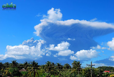
Recent eruptions have been recorded that happened in 2006, 2007, 2010 and 2011. 

Bulusan Volcano Eruption last Feb. 20, 2011 at around 9AM


Trail from Bulusan Lake to Summit


Sources of information:


Tuesday, March 1, 2011

PinoyMountaineer Difficulty Scale (2009)

PinoyMountaineer recommends the classification of Philippine mountains according to difficulty with a numeric scale of 1-9 with the purpose of guiding enabling hikers to prepare accordingly. There are limitations to the criteria, and the PULAG factors listed below will try to account for some of these. The Difficulty scale is subject to continuous re-evaluation and editions will be released annually.

D
Representative Destinations
Criteria
1
Seven Lakes of San Pablo
Daranak and Batlag Falls
Mt. Samat
Very easy: treks less than 30 minutes in paved/cemented roads or clear paths
2
Mt. Maculot
Mt. Romelo
Gulugod Baboy
Easy: Single trail lasting less than 2 hours in length, not exceeding class 2.
3
Mt. Batulao
Anawangin Cove
Mt. Cinco Picos
Mild: Trail requiring less than 2 hours but with parts exceeding class 3; or 2-5 hours in length but not exceeding class 2.
4
Mt. Makiling
Mt. Cristobal
Tarak Ridge
Mt. Hibok-Hibok
Average: Trail requiring 2-5 hours, with parts of trail class 3 or higher; or trek lasting 5-9 hours, with parts of trail not exceeding class 2
5
Mt. Makiling Traverse
Mt. Arayat Traverse
Mt. Banahaw (Dolores)
Moderate: Trail lasting 5-9 hours with parts of trail class 3 or higher; or all long treks not exceeding class 2.
6
Mt. Ugu Traverse
Mt. Isarog (Patag-Patag)
Mt. Tapulao
Challenging: Mountains under class 5 with place-specific circumstances not accounted for by trail class.
7
Mt. Pulag (Akiki-Ambangeg)
Mt. Napulauan Traverse
Mt. Amuyao Traverse
Difficult: Trek lasting 5-9 hours, with parts of trail class 4 or higher with cold weather OR trek requiring 3 or more days
8
Mt. Apo Traverse
Dulang-Dulang-Kitanglad
Mt. Kanlaon Traverse
Strenuous: treks requiring more than 3 days average with varied, potentially hazardous environments or Trail class 5-6 for 2 hours
9
Mt. Halcon
Mt. Guiting-Guiting
Mt. Mantalingajan
Mt. Kalatungan
Technical: Either Trail class 5-6 more than 8 hours or very long treks requiring 4 days average or less than 3 days but exploratory in nature and summitability non-assured.

*The
PULAG factors add +1 to the difficulty of the trek:
P- Precipitation > 50% of trek time
U- Unestablished trail or flooded trails requiring water-crossing
L- Low temperature; <> 35 C)
A- Animals or wildlife that interfere with trek (i.e. hyperlimatik)
G- Gusts of wind reaching >50kph

Source: http://www.pinoymountaineer.com/2008/11/pinoymountaineer-difficulty-scale-2009.html

New System of Classifying Mountains


PinoyMountaineer.com classification system, version 1
by Gideon Lasco

To address the need for a more precise classification, PinoyMountaineer is adopting a new system which will enable the classification and characterization not just of mountains but of all outdoor destinations in the Philippines.

The old 'fact sheet' we used consisted of (1) elevation; (2) level; and (3) days required. Among these three, only 'Level' gives an idea of difficulty. Elevation is useless because what is more important is altitude gain. Furthermore, the old system do not have an idea of how long it takes an average climber to reach the summit, which is considered by many as an important gauge to assess a climb. Finally, a three-level system does not distinguish between DIFFICULT and VERY DIFFUCULT or EASY and VERY EASY.

Thus, we are adopting a new difficulty scale, of 9 grades. This system is RELATIVE scale that is used to compare one mountain with another. Mt. Guiting-Guiting, Mt. Halcon, and Mt. Patukan are considered 9/9 and the minor waterfalls trips are 1/9. Length of the hike, preparations required, including the travel time from the nearest major city (i.e. Manila, Baguio, Davao), as well as extremes of environment are considered. The most commonly used trail is considered for each mountain; articles featuring a particular trail will have their own classification apart from the mountain itself: Akiki Trail is 7/9 whereas Ambangeg is 5/9. This system is primarily for local mountaineers who have experienced climbing the mountains themselves.

Major/Minor classification: This has been used by local mountaineers, but we are making the distinction more exact: Destinations that can be negotiated within 5 hours (i.e. can be daytripped) without extraordinary effort are considered MINOR; the rest are considered MAJOR. The label "climb" is avoided as outdoor destinations may be likewise classified. The Level I-IV system is abolished.

Another addition is "Trail class". It is an internationally-recognizable, ABSOLUTE scale:

1 - Walking (easy stroll)
2 - Hiking along a path/rugged terrain
3 - Scrambling (using hands for balance)
4 - Climbing easy cliffs but with enough drop off- beginners should be roped.
5 - Using free hands as climbing method
6 - very difficult and need to use artificial method

Since most climbs involve different trail classes, the most predominant class is put first, with other legs put in parenthesis. Required maneuvers, such as river crossing, rappelling, or swimming will also be included. We are including this so that foreign visitors will have an idea what a particular mountain would entail in terms of preparations. There are other international scales; others include the amount of energy (calories) a climber would use but these systems are still impractical for our setting.

These three, (1) Difficulty scale; (2) Major/minor classification; and (3) Trail class form the "Specs" of each outdoor destination. We have a basic Major/Minor classification, adopted from the old itineraries; we also have a relative scale as well as an absolute scale. Finally, the "Specs" can be applied universally and can be understood universally also.

Here are examples of the proposed "Specs":

Taytay Falls: Minor, Difficulty 1/9, Trail Class 1
Mt. Maculot: Minor, Difficulty 2/9, Trail Class 2-3
Mt. Batulao: Minor, Difficulty 3/9, Trail Class 2-3
Tarak Ridge: Major, Difficulty 4/9, Trail Class 2-3
Mt. Pulag via Ambangeg: Major, Difficulty 5/9, Trail Class 2
Mt. Tapulao: Major, Difficulty 6/9, Trail Class 2
Mt. Apo via Kidapawan: Major, Difficulty 7/9, Trail Class 2-4
Mt. Dulang-Dulang: Major, Difficulty 8/9, Trail Class 2-4
Mt. Patukan: Major, Difficulty 9/9, Trail Class 2 with rappelling, river crossing

In addition, "hours to summit" and "days required" will be included in the primary information parameters included in each article. These, however, are admittedly subjective, and serves only as a guide. Finally, instead of just mentioning altitude, LLA (latitude, longitude, alitude) is given, together with altitude gain.

These specs will be used in future articles, and past entries will soon be edited to adopt this system. Feedback from blog readers is highly encouraged to further enhance this system.